 |
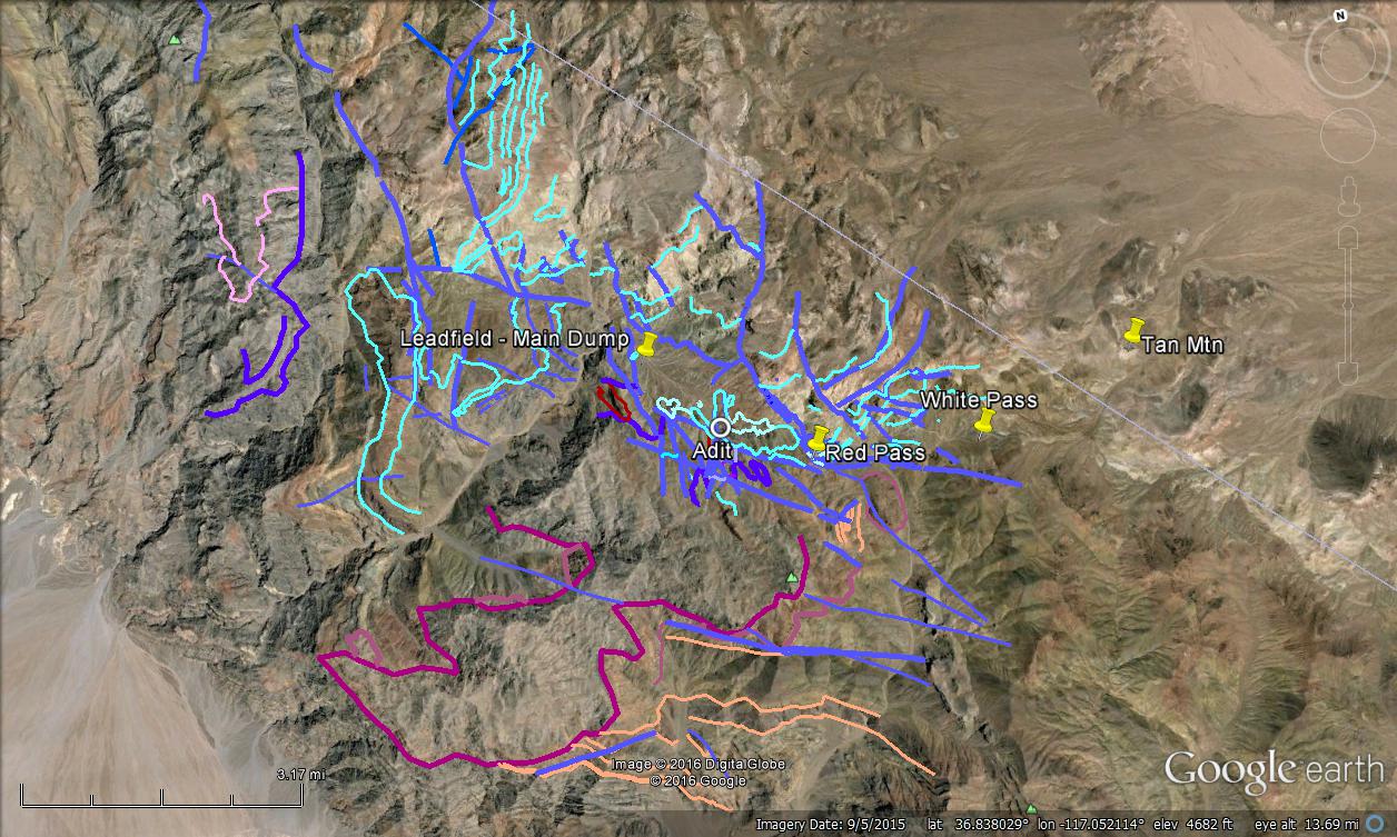
| Geologic contacts are in cyan and other colors; faults are thicker lines in dark blue, dark purple, and magenta. Geology is modified from Niemi (2012) and Reynolds (1974, also as seen in Lengner and Troxel, 2008). |
There are three branches to upper Titus Canyon. The longest branch, the northern or western, runs about 5 miles almost due south from its headwaters near Alkali Spring; this branch is labeled Titus Canyon on topo maps. The second longest branch, the southern or southeastern, runs about 2.5 miles northwest from Red Pass; though unnamed, we're calling this branch Lost Canyon after Lengner and Troxel (2008) and others. A third branch, the eastern or middle, runs about 2.4 miles southwest from headwaters in the volcanic hills near the California-Nevada border; this branch is also unnamed, and I'm not aware of any local or regional designations for it. The three branches meet just below Leadfield.
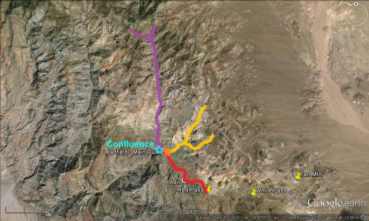 |
| The three branches of upper Titus Canyon: The main, west or north branch, aka Titus Canyon, is in purple; the unnamed middle or east branch is in yellow; and the unnamed southeast or south branch, aka Lost Canyon, is in red. |
 |
| Beyond the gray Tertiary megabreccia immediately on our left (south), I spy the maroon color often indicative of Cambrian Zabriskie Quartzite (Cz). |
 |
| We've been calling this cliffy hill "Tc Hill" for the reddish brown formation that caps it, although we could have gone with "Tm Hill" for the Timber Mountain Group tuffs that we can't see beyond and above the upper, dark brown cliff. |
 |
| Tc Hill, with some geologic formations and a few contacts drawn in. |
 |
| This part of the countryside reminds me of those wonderful desert paintings by Georgia O'Keeffe. |
 |
| Red rocks on a pink, yellow, and green slope. |
The road continues on. The contact between the lower Titus Canyon Formation and the underlying Cambrian units (that's quite an unconformity between the Cambrian and the Eocene!) is now almost immediately south of the road, between us and the main dry wash of upper Lost Canyon. As we cross several rills and washes coming off the cliff to the north, we'll pass low slopes of gray Carrara Formation and bulges of dark gray Bonanza King Formation. If we look closely, we might spot a few old workings dug into these older formations, hinting that we're getting close to the old mining camp at Leadfield.
Now, as we near the end of the reddish upland, the road swings wide and to the south, and we're suddenly aiming toward a lumpy hill of dark gray rock. This is one of several large bodies of megabreccia composed of limestone fragments and blocks (limestone and dolomite?), which lie at or near the base of the Titus Canyon Formation. Stock and Bode (1935), who described and defined the Titus Canyon Formation shortly after H. Donald Curry's discovery of a Titanothere in what became known as Titanothere Canyon (Protitanops curryi, now part of the Brontothere family; read more about this story at Geotripper), included the "limestone breccia" as a basal part of the larger Titus Canyon Formation. In the many times I've driven by these breccia bodies, I've always assumed they were part of the Paleozoic section of the area! Next time...
 |
| The reddish road, pointing toward a jumble of dark gray rocks in this Google Earth ground-level view, is about to make a tight turn to the right. |
Now that we've passed this tight curve, the road has a steep drop off to the dry wash immediately to the left. Across the wash, there's a great view of one of the larger dumps of the Leadfield mining camp.
 |
| A partly wash-eroded mine dump sits below a large, dark gray outcrop of Tertiary megabreccia. Cambrian Zabriskie Quartzite forms a maroon cliff in the upper part of the photo. |
A first thing to note is that there is a fair amount of iron oxide on the dump—and on the rock outcrop immediately to the right of the dump, and also on the slope coming off of the Fe-oxide-barren dark gray carbonate breccia (reportedly the breccia might consist of both limestone and dolomite). The iron oxides consist of goethite, hematite, and jarosite based solely on the color seen in these photos (hopefully the color balance of the photos is good), the oxides are leaning toward goethite and jarosite. (Here, I'm using the old porphyry copper, Bear Creek–originated triad of hematite-goethite-jarosite, even though jarosite is technically a sulfate, not an iron oxide. Someday I'll have to try to do a color triangle to show what we used to use.)
Secondly, I'd like to note that someone took the time and effort to shore up the flat area in front of the adit feeding this dump with fairly cruddy hand rocking (left of the dump and best seen in my next photo).
 |
| Here you can see the dump and rock wall a little better. The adit opening is behind a largish creosote(?) bush. |
The biggest anomaly I see in the photo is the abrupt, semi-linear contact between the unoxidized, cliff-forming dark gray rocks and the oxide-bearing, slope-forming grayish orange rocks. It's possible that the oldtimers were trying to hit this contact. Maybe there was a little indication of "mineral" upslope, maybe not. It's a little hard to for me to imagine that this particular dump was created solely as part of a stock scam, as has often been claimed for nearly the entirety of the Leadfield camp.
That is, if I was doing any exploration in this area (I don't conduct exploration in National Parks or Monuments; it doesn't pay), I'd be remiss if I didn't take at least one sample from this dump, and if I didn't try to find something to sample either in the back or ribs at the adit opening, or on the hill above it. Maybe I'd only try to grab (select, or "high-grade") a sample of iron oxides in blebs, veinlets, or on fractures. I'd also be remiss if I didn't at least look for a "goody pile" left by the last claimholders, although erosion by the wash might have taken it away.
So much for armchair exploration! Here's a bit of the geology near the adit:
 |
| Cbl = Cambrian Bonanza King Formation (should be "Cb or Cbk"); EOgtc = Eocene to Oligocene Titus Canyon Formation; Mbx = Tertiary/Paleogene, probably Eocene megabreccia in or at the base of the EOgtc. |
 |
| The road passes over a barely scraped, overhung exposure of Tertiary megabreccia. |
 |
| From this trailhead you can hike the short distance to the mine dump we just viewed, and one or two other dumps along the way. |
 |
| Most mine adits and shafts don't have all these hazards, but most have a few to several. Don't go in if you don't know what you are doing, and don't assume you know what you are doing. It's my humble opinion that you don't. |
A Few References:
Lengner, K., and Troxel, B.W., 2008, Death Valley's Titus Canyon & Leadfield ghost town: Deep Enough Press, 175 p.
Niemi, N.A., 2012, Geologic Map of the Central Grapevine Mountains, Inyo County, California, and Esmeralda and Nye Counties, Nevada: Nevada, Geological Society of America Digital Maps and Charts Series, DMC12, 1:48,000, 28 p. text.
Reynolds, M.W., 1969, Stratigraphy and structural geology of the Titus andTitanothere canyons area, Death Valley, California [Ph.D. thesis; not available online]: Berkeley, University of California, 310 p.
Reynolds, M.W., 1974, Geology of the Grapevine Mountains, Death Valley,California; a summary, in Death Valley region, California and Nevada, Geological Society of America Cordilleran Section, Field Trip 1 Guidebook: Death Valley Publishing Company, Shoshone, California, p. 91–97.
Snow, J.K., and Lux, D.R., 1999, Tectono-sequence stratigraphy of Tertiaryrocks in the Cottonwood Mountain and northern Death Valley area, Californiaand Nevada, in Wright, L.A. and Troxel, B.W. eds., Cenozoic basinsof the Death Valley region: Geological Society of America Special Paper 333, p. 17–64.
Related Posts:
The Approach to Titus Canyon: Tan Mountain
The Approach to Titus Canyon: Up and over White Pass
The Approach to Titus Canyon: To Red Pass
The Approach to Titus Canyon: Just Below Red Pass
A Hike at Red Pass, Titus Canyon Road, Death Valley, CA
Titus Canyon Road: A Little History and a Few Maps
Down into Titus Canyon: We Leave Red Pass Behind (Finally!)
No comments:
Post a Comment