On
the road to Silver Peak from the east, about six or seven miles past Alkali and while one is still on pavement, Clayton Valley comes into view. The road turns to dirt—gravel and dust—not far beyond this first photo, and not far before the second.
 |
| Panoramic view of Clayton Valley in front of the eastern nose of Mineral Ridge. |
 |
| The same photo, labelled. |
In this view, we're looking at Mineral Ridge nearly end-on, essentially down the axis of the mountain-sized anticline that it is. Mineral Ridge, Red Mountain, and the ridgeline on the far left are all part of the greater Silver Peak Range. The ridge, with its high point of 9376 feet (2858 m), hides the range's high point,
Piper Peak, and also blocks any view of the
Mohawk and
Sanger Mines beyond. The reddish brown, dome-shaped
Red Mountain, composed of Tertiary rhyolite (Albers and Stewart, 1972), sits at 8957 feet (2730 m) just in front of and to the right of the unnamed ridge. Silver Peak itself is barely in the picture in the left side of the photo—you can see little hints of green if you look closely—just beyond the lithium brine fields of Clayton Valley. The low green slopes on the either side of the dirt road in the foreground consist of natural outcrops of olive to bluish-green shale of the Cambrian
Harkless Formation. We'll see more of the cinder cone, The Crater, later in this Silver Peak portion of LFD's
thesis-hunting series.
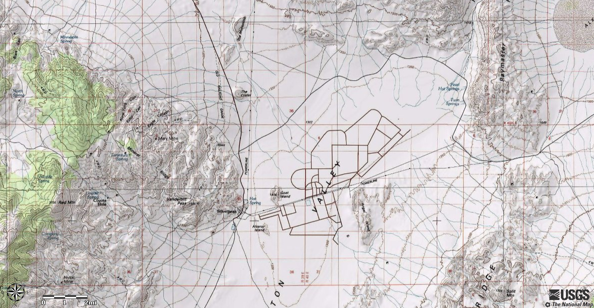
 |
| Labelled aerial view of the Clayton Valley–Silver Peak area, courtesy USGS (TNM Viewer link). The lithium brine fields are dead center. "You Are Here" marks the site of the previous photo. |
Past the gap between the north end of Clayton Ridge and the south end of Paymaster Ridge, Silver Peak Road begins to cross the ever-changing lithium-brine fields and ponds. It turns out that there’s a more direct way to Silver Peak from the Palmetto Mountains on dirt via Oasis Divide (off the southwest edge of the map above), but fortunately I didn’t try it back in 1976. It’s a usually washboardy, tire-spinning, sandy road, with lots of inconvenient turns. I doubt the Opel would have made it.
So there I was, finally crossing the large, lithium-brine mining operations in Clayton Valley. (Photos are all from a photo-gathering expedition I made in the summer of 2010.)
 |
| Sign near the middle of the lithium brine fields. |
The lithium operation, run by
Chemetall Foote Corporation back in 2010 according to these signs, is now supposedly
owned and run by Albemarle Corporation. Back in '76, it was run by Foote Mineral Company. (The brine mining operation has undergone several name changes over the years.)
 |
| More signs. |
I'm not really sure what I thought of the lithium brine fields when I traversed the playa from east to west back in 1976, but I probably felt conspicuous and out-of-place. (This was a common feeling during my thesis-hunting adventures: An Opel was fairly uncommon vehicle overall and was even more uncommon off pavement, dirt roads and the Nevada outback were unfamiliar to me, and I was persistently plagued by the thought that I didn't know what I was doing.) Even now, making the crossing can seem a little strange to me, although I did become accustomed to going back and forth across the brine fields back in the mid-1980s when I worked on top of Mineral Ridge. What's odd about the crossing? It's unusual to find such a major dirt road traversing a playa, and what with the all the power and phone lines on both sides, the visual impression is unique. The traffic can be heavier than one usually finds on a playa (barring unexpectedly being on the Black Rock Desert during Burning Man), and one has to watch for trucks and construction equipment.
 |
| Silver Peak: about four more miles. |
 |
| Off to the northwest, the dark prominence of The Crater, a basalt cinder cone, stands out above the salty desert floor. |
 |
| And there we are: the south end of Silver Peak is to the right. |
Read a little more about the brine fields
here (USGS, basic info apparently from 1982, still relevant),
here (the origin of the brine fields), and
here.
Related Posts:
Thesis: Finding an Area
Finding a Thesis: Battle Mountain to Austin to Gabbs
Finding a Thesis: Pole Line Road
Finding a Thesis: Pole Line to Belmont
Finding a Thesis: Klondyke District
Finding a Thesis: A Joshua Tree Aside
Finding a Thesis: Into the Palmetto Mountains
Finding a Thesis: Farther into the Palmetto Mountains
Finding a Thesis: A Bit O' Geology in the Palmetto Mountains
Finding a Thesis: Future Stories from the Palmetto Mountains
Lida Summit Roadcut
Finding a Thesis: Next Stop, Silver Peak!


No comments:
Post a Comment